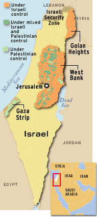
The APARTHEID MAPS
Nowhere else in the world is there anything of
this kind. Only when the South African White government drew up the "Apartheid"
plans of the 1970s did a pattern of this kind exist elsewhere other than
the Israeli occupied territories -- and those Bantustans are now gone.
Beyond the maps, the Israelis enforce a regime of computerized and colored
passes r estricting
where Palestinians can go, different color license plates for Jews and
Arabs with similar result, "by-pass" roads for "Jews only", land confiscations,
home destructions, settlements, all on top of a deceptive and complicated
systems of apartheid-type laws that create systematic separation while
promoting Jewish interests and severely repressing and dispossessing Palestinians.
The changes agreed to recently in the "Wye Memorandum" do not change these
overall conditions and are hedged with so many Israeli restrictions that
the situation even becomes worse than before for Palestinians.
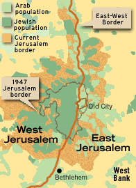
 Since
1967 the Israelis have continually expanded Jerusalem, claiming it is not
part of the West Bank, and thus not including it in the inflated percentages
that are used to make it seem the Palestinians are "getting back" more
than is actually true. Even this map doesn't show the full extent of how
the Israelis have recently still further expanded Jerusalem to encompass
nearby settlements and the city of Ma'ale Adunim, the green area on the
extreme right.
M
I D - E A S T R E A L I T I E S
(202)
362-5266
Fax: (202) 362-6965
MER@MiddleEast.Org
******************************************************************
For
information about the weekly TV program,
MID-EAST
REALITIES, send email to
INFORMER@MiddleEast.Org.
******************************************************************
For
previous MER information, commentary, editorials & Readers Comments:
http://WWW.MiddleEast.Org